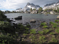


My fourth adventure in the wilderness. I'm hooked! This was a great hike and a very popular trail, which means -- we saw a lot of other hikers. The Rush Creek trail is challenging with the elevation gain. We day hiked to Thousand Island Lakes, once we reached the John Muir Trail, and this hike was saturated with gorgeous views -- every direction you looked was a postcard view. Going through Donahue pass was also a challenging hike -- but worth it! It was cold, windy and desolate looking at the top -- beautiful! For the most part the weather was average, except for the last day when snow was predicted about 8000 ft. We got snowed on while we hiked out and the temps were most likely in the 40's in Lyell Canyon (per park ranger).
Start: Rush Creek Trailhead near June Lake.
End: Toulumne Meadows in Yosemite
The Plan: Park at Toulumne Meadows and take YARTS bus to Rush Creek Trailhead. (Our bus driver was new and didn't know the Rush Creek stop. Thankfully a local was on the bus and told the driver where to stop.) Hike back to car via John Muir Trail. Parking in Yosemite is free. Rent bear food canisters in Yosemite.
Permits: Barely squeaked out a 2 person permit from Inyo National Forest. Was told August is the busiest month. If you go -- get permits as soon as you can!
Approx. total hiking mileage is: 35 miles or so. 2 nights camping, 3 days hiking .
Highlights: view of Thousand Island Lake, Island Pass,Donahue Pass (11056 elevation)
Weather: Summers in the Sierra are warm and dry. Yosemite receives less than five percent of its annual precipitation in summer, mostly as rain from thunderstorms. Daytime temperatures in Yosemite Valley sometimes reach 100°F during summer, while nights are cool. Temperatures in Tuolumne Meadows (8,600 feet) in mid-summer are usually in the 70s in the daytime and in the 30s at night. Though skies are usually clear, thunderstorms can be a daily occurrence in summer afternoons. Usually forming at higher elevations, thunderstorms form suddenly and can provide intense but brief downpours, lightning, thunder, hail, and gusty winds. Typically, by nightfall skies are clear once again.
Who is going: I only have a permit for two. Most trailheads in the parks in this area have a quota of how many people can start on them per day.


2 comments:
I'm going to have to get out my maps and see where Rush Creek/June Lake is at... Is it south of the meadows? I did the JMT in the 90s--in three parts, the last hike being a 5 or 6 nighter from Mammonth to the Yosemite Valley
Sage -- Sorry I didn't notice your comment before. Rush Creek is south and east of Meadows. I got my permits to hike from Inyo National Forest (I think). You can see the trail on the JMT maps -- although it is not marked on maps -- the trailhead starts at Silver Lake and you hike past Agnew Lake and Gem Lake.
Post a Comment