Monday

COMPLETED: Grand Canyon Hike - To the Colorado River and Back in a Day -- April 2019


Morning on the South Kaibab Trail
First let me tell you that the National Park Service does not recommend this hike.  It is very strenuous -- the hardest part is hiking back out of the canyon.  However, my husband and I are in good physical shape, and did not have a problem completing the hike.  The hike was 19 miles long and took us 10 hours.  If we had hiked without stopping, it would have taken us 7 hours -- but we took our time and had a long lunch at Phantom Ranch and took long breaks in a few other areas -- and generally stopped and "smelled the roses".  We did see some people struggling to hike out of the canyon -- one woman was very distressed and she was still 4 miles down with the 4 hardest miles to hike out yet in front of her.  So be careful!

We woke up at 5:30 a.m., packed up our things and got in the car to drive to the Grand Canyon.  We were staying in Williams and our drive to the canyon was about 1 hour.  At the canyon we parked and got on the shuttle bus that would take us to the South Kaibab Trail.  Our plan was to hike down this trail, have lunch at Phantom Ranch and then hike back to the rim on the Bright Angel Trail.  We did this route because we knew that the Bright Angel Trail had a water supply on it at Indian Garden.  Our hike ended at around 5:00 p.m. at the rim.

We took one day pack filled with both of our needs for the day and then we alternated carrying it.  Our pack had 3 bottles of water (32 oz each).  We had food for lunch and snacks.  Take sunscreen.   We both wore hats.  Just in case it got late and dark on our way out, I packed a flashlight and a headlamp (we didn't need these though).

Switchbacks on South Kaibab Trail
The South Kaibab Trail gives you spectacular views right away -- and you should reach Ooh Aah Point in about 20 minutes.  If you want to hike part way into the canyon and out, take this trail.  The Bright Angel Trail does not give you great views until about mile 3 or 4.  You might see mule trains when you hike - remember they have the right of way - step off the trail at a safe place to let them pass.  You will see the Colorado River come into view.  You might see raft boats at a little beach by the suspension bridge.  You will cross over the bridge and you can hike to Phantom Ranch or continue on, cross the second suspension bridge back over the Colorado and get on the Bright Angel Trail and go back up.  We decided to check out Phantom Ranch.

Phantom Ranch has a restaurant and picnic tables outside and tables inside to sit at.  You can purchase lemonade for $4.75 a glass with refills being $1.  There are other beverages and snacks you can purchase there too.  When we were there it was lunch time and the place was filled with hikers eating and lounging.  The picnic tables were filled and we sat on the grass and enjoyed a little rest.  There are bathrooms here as well.

Hiking to Indian Garden
The hike back up to the rim on the Bright Angel Trail is a treat.  There are several bubbling brooks and at one we took off our shoes and washed our feet (Pine Creek).  We were here in April, so not sure if these dry up more in the heat of the summer.  The hike to Indian Garden was beautiful.  It was another oasis spot -- the cottonwood trees were snowing their cotton, birds were singing, the wind was blowing gently -- it was enchanting!  There is a water spigot and a bathroom at Indian Garden - you can't miss it - both are right by the trail.

The last 4 miles up on the Bright Angel Trail are the hardest.  We were hiking at a rate of about 2 miles per hour and gaining approx 700 feet of elevation each mile.  I believe that the Bright Angel is an easier hike out than the South Kaibab though -- according to my calculations, on that trail you would have 5 miles of 700 feet gains and 2 miles of 500 feet gains.  Of course, my data from the South Kaibab is based on our descent and we were moving a bit faster going down.  But I do believe the South Kaibab would be steeper and a harder hike, even though it is 2 miles shorter than the Bright Angel.

Hiking into the canyon is a great way to experience the grandeur of the canyon.  You don't have to hike to the Colorado to get this -- just hike down a mile or two -- or as many as you think you can safely hike out.

Map:  National Geographic Grand Canyon Map

Tuesday

COMPLETED: Hike Up Mt. Katahdin -- Baxter State Park, Maine --August 2018

Thru-hikers finishing their 2189.1 mile AT journey on top of Mt. Katadyn.
My husband and I hiked up Mt. Katahdin in August.  We were told by the park rangers that the parking lot to the trailhead filled up quickly and once it was filled up, no more hikers could go up that trail.  So we got up early and got to the Katahdin Stream Trailhead (Hunt Trail) at about 6:15 a.m.  We were the third car there (the lot fits 15+ cars?).

I took a small daypack with lunch and water in it.  I also took a water filtering bottle, which we filled up at the last water source.  We still ran out of water!   I suggest taking at least  2 Nalgenes full of water (each Nalgene having 32 oz. each of water).  Also, it is a park rule that each hiker has to have a flashlight.  (If rangers decide to check hikers and you don't have one, there is a fine.)

The hike was a very tough hike.  The toughest hike I have been on - ever!  Pretty much it was like being on a stair master on the way up!  Once you get closer to the top, then you start climbing over boulders!  In a few places there were iron handbars attached to the rocks to help you pull your self up.  Going up, I wondered how I would ease myself down from a couple spots.

Once at the top, you are rewarded with spectacular views.  Our views were obstructed by fog after awhile.  We saw about 20 people finish their hike of the Appalachian Trail.  Wow, were they all in shape!

Going down, we decided to take the Abol Trail, which were heard wasn't as steep.  It was still difficult and I slide myself down rocks on my bum!  But maybe it is my age -- I saw some 20 somethings jumping from rock to rock like they were mountain goats!

The hike took us about 8 hours.  Once back to the Abol Trailhead we had a 2 mile walk to the car, except that a man we hiked with said he'd take us back to Katahdin Stream Trailhead in the back of his pickup.

This was a spectacular hike though.  We rated it our top experience in Maine.  If you decide to do this hike, I suggest camping in the park the night before.   This way you have a jump on all the others coming into the park that day and also want to hike to the top.  The rangers say that people start lining up at the gate at 4:00 a.m.  If Katahdin Stream Trailhead parking lot is full, you can try the Abol Trailhead and maybe even Roaring Brook.  I don't know anything about Roaring Brook and the trails to the top, except that I have heard the Knifes Edge Trail is really tough!

If you decide to camp in this park, you will need to take in all our water (or boil or filter the water from the lakes around you).  You also have to pack out your trash.  We rented a cabin (on Kidney Pond) for a couple nights and it had beds, chairs, a deck for cooking on and inside was a wood stove to keep you warm at night.  We used the wood stove - even in August!  Beware -- there are mice -- best to keep all food and other items in plastic totes.  Life for a couple days on Kidney Pond was gorgeous!  We heard the eerie cry of the loon often.  There are canoe's you can rent for $1 an hour and we went out both nights and searched for the baby loons we heard were on the lake.  We found them!  Mom and Dad loon were diligently feeding their two babies.  Fun to see!

COMPLETED: Mickelson Trail -- Black Hills, SD -- June 2017

In June, I hiked part of the Mickelson Trail.  This is really a biking trail and it is a lovely one!  The path is crushed limestone and great for biking and also super nice for an easy hike.  You don't have to hike over roots and rocks.   I went with two friends and one friend hiked and one rode a recumbent bike.

We parked the car in Pringle, SD at the trailhead.  Pringle is a small town and we wondered if our car would be safe there and our shuttle driver assured us it would be just fine.  Then we took a shuttle up to Deadwood to start the hike/bike.  I can't remember exactly what shuttle we used but our shuttle driver was named Bill and was very knowledgeable about the trail and South Dakota history.

This first night on the trail we stayed in cabins that are along the trail.  We had all our own food in our packs and bike bag so once we got to the cabins and checked in, we used the microwave to cook up some ramon noodles.  It was nice to take a shower and have a bed to sleep in.

The second night we slept along the trail.  During the day while we were hiking and biking, we ran into a man who was riding the trail as the Mickelson Trail Bike Patrol.  He checks to see if people have their permit to ride the trail.  (We got a yearly permit for $15 each.)  He was also helpful in telling us where we could camp along the trail.  A lot of the land is private land and he steered us clear of that and told us where some federal land was that we could camp on.  It is important to NOT upset the neighbors and private land owners along these recreational trails.  

The third night, we slept in a hotel in Hill City.  And we had a super meal at a restaurant there called the Alpine Inn.  

Our adventure on the trail was finished after this.  I'd recommend the trail more for those who are biking as you can get to a campground or hotel easier on bike each night, than you can on foot.  The trail is over 100 miles long - I think a lot of the trail used to be an old railroad track.  The trail goes through several short tunnels.  Often in the hills, there are spots where there is no cell service.  At many of the trailheads there is a toilet and a pump for drinkable water.  

My friends and I hiked/biked approximately 50 miles of the trail.  It was a fun adventure and it was so nice to have all this time to catch up with my out-of-state friends!

Monday

COMPLETED - Superior Hiking Trail - MN - 29 miles - Sept 2016

View from ridge line
Split Rock River
Miles hiked:  approximately 29
Map used:  Map 3 of 6 that was bought from Superior Hiking Trail Association
Guide Book:  Guide to the Superior Hiking Trail, 7th addition
When: late September
What:  section hike of Superior Hiking Trail


We parked at the trailhead on West Castle Danger Road and used the Superior Shuttle Service for transport up to the trailhead on Lax Lake Road or Road #4.  We started the hike around 9:30 a.m.  The plan was to hike shorter days - 8 miles or so.  The first night we set up camp at Christmas Tree Ridge at 3:00 p.m.  We rested for about 2 hours and then we were restless, so we packed up all our stuff, took the tent down and continued on.  We ended up hiking until dark and found a campsite on the Split Rock River.  We think we hiked about 12 miles.  Wow, did I ever sleep good that night!  The cool temps were great for sleeping, plus we had the sound of the rushing river next to us - and I was so exhausted that I feel asleep fast and hard.

The next night we had another long day of hiking and camped by the Gooseberry River.  The hubby made a nice little fire, which was very warming since the temperatures fell at night.  He got the fire going again the next morning, and after breakfast and coffee , we continued on and were finished with the hike around 11:00 a.m.  We then went and treated ourselves to lunch at a local restaurant.

This was a nice hike if you don't mind hiking in a more populated area.  Once you are in the woods, you are on your own, but from the sweeping views on the ridgeline, you will see the highway and evidence of the human race.  If you ran into trouble, you are very close to civilization.

All the rivers we hiked over had bridges.  On this trail you are to camp in the designated camp sites -- you can't just camp where ever you like.  The views of Lake Superior are gorgeous when you are up on the ridge.  We drank water out of the Split Rock River (we filtered it) and it tasted better than the water we took from home, despite the tannins in the water.  The trail had a little detour north of Gooseberry State Park.  Apparently, a lot of the trail runs on private property and the landowner by Gooseberry State Park had pulled the plug on allowing use of his land due to improper use.  So for a couple miles, you walk on the Gitchie Gamie Bike Trail.

The section we hiked is probably one of the more popular sections that people hike probably because it is close to two state parks.  You can hike the whole trail if you want - it is 296 miles or so from Duluth all the way up to the Canadian border.  It is marked by blue blazes.  You have to camp at the designated tent pads and if you have a fire, they are to be built in the fire rings.  You don't need a permit to hike - just hop on the trail and go!

We had a wonderful time in the north woods!  There weren't any bugs, we saw only a few hikers this time of year and the weather was great!  Plus, Duluth is a neat city to hang out in after the hike is over.  With hiking trails, bike trails, and the big lake so close -- the "North Shore" as they call it -- is a outdoor enthusiasts dream!

Saturday

Hiking Essentials: A Duct Tape and Red Bandana Kind of Glamour

I once traversed Zion National Park on foot.  It was a fifty mile hike and it was a total blast.  The following is a story I tell often about that hike.  

On the third day of the hike we reached Zion Canyon and walked down Walter's Wiggles to the Canyon.  Zion Canyon and the Walter's Wiggles Trail are full of tourists.  Full of them.  As I walked down the trail with my pack on my back, I was hit by all the clean fresh smells of the tourists -- lotions and shampooed hair, to name a few.  As I wondered how I smelled and looked to them, I suddenly found that I was somewhat of a celebrity!  Many people stopped me to talk about what I was doing.    Other people just gawked and some people secretly took my photo!  Looking back, it might have been my shining moment in life.  If only they had known how very unglamorous I felt!

I'd been bathing in streams using the bandana I was wearing around my head as a wash cloth.  I had also hiked one morning with my sleeping bag wrapped around me because we woke up to a surprise layer of snow and freezing temperatures and I didn't have warm enough clothes with me. And underneath my socks, my toes and heels were covered in gray duct tape to combat my many blisters.  I was as unglamorous as a person could get and yet, I think what I was doing excited the imaginations of many of those fine people who made me feel like a celebrity!

I'm a big fan of lightweight backpacking and I pack as little as possible. I have a women's Deuter pack.   I try to get my pack weight to 20 to 25 lbs (excluding water). Since I usually hike with another person, we split the weight of shared items like tent, cooking supplies and safety kit.  It's a more enjoyable hiking experience if your pack isn't too heavy. You find that you really don't need all kinds of stuff anyway.  For me, it is the bandana and the duct tape that go on every hike.  They both have multiple uses.  The bandana can be a sweatband and a hat; douse it with water and wear it to cool yourself off, and of course, it's a great washcloth for bathing.  Duct tape is great for blisters and can be used to repair tents, packs, shoes, etc.

So maybe I wasn't all that glamorous on the outside with my dirty bandana and my blistered feet.  But that day in Zion Canyon, I was carrying everything I needed on my back.  I was out roughing it in the wilderness.  When you are out there, your soul is being fed with the spectacularness of it all: the wide vistas, owl hoots, boulder rivers, tall trees and rushing streams.  You're out there in the wind, dust, rain, snow and heat.  You never know what will happen and the gloriousness and wonder of it all shines through.  I was happy and it showed.   Is it possible, that maybe the hiking glow is glamorous -- despite the duct tape and dirty red bandana? 

Below is a list of things I'll put in my pack this summer when I hike the Maroon Bells in Colorado. Happy Trails!

* * * * *
  • Down Sleeping Bag
  • Sleeping Pad
  • Two Person Tent (usually I don't take the stakes or the tarp that goes underneath)
  • Kettle (for boiling water)
  • Compact Stove, fuel canisters, lighter
  • Safety Kit (whistle, ibuprofen, duct tape, bandaids, water purification tablets, tweezers, Chapstick, etc.)
  • At least four or five 32 oz. Nalgene bottles
  • A filtering water bottle
  • Clothes: 2 pairs socks, 1 pair spandex shorts, 1 pair long pants, 2 shirts (not cotton), 2 undies, 2 bras, sweatshirt (Clothing items could be less, could be more depending on where I'm hiking.)
  • Lightweight sandals for camp that you can also cross rivers/streams in
  • Hiking Shoes - I usually hike in a pair of my old running shoes - or shoes one size too big if I'm hiking in heat because my feet swell from the heat. The shoes need to be sturdy enough to handle rocky surfaces.
  • Prescription Sunglasses 
  • Glasses
  • Paperback Book (Swap out books with your hiking buddies)
  • Wide Brimmed Hat (for ears and neck sun protection)
  • Bandana
  • Camera Equipment
  • Maps
  • Toiletry bag:  toothbrush, biodegradable soap, toothpaste, comb, ponytail holders
  • Food bag (a sampling of items I put in):  a dehydrated dinner for each night, McCann's Irish oatmeal packet for each morning or lunch, granola bars, Clif bars, dried apples, a packet or two of Ramon noodles (they satisfy the salt craving), crackers, Nutella, beef jerky, single serve coffee packets ... Remember to eat all the heavier items first!
  • Plastic Mug for coffee and oatmeal, a Spork
  • Racko Game
  • Lightweight Light to hang inside tent 
  • Old Ski Pole to use as a walking stick
  • Pen and Paper for journalizing
  • ID, credit card and some money
  • Cellphone
  • A few plastic bags to put trash in to follow Leave No Trace policy.  You can also use your used dehydrated dinner bags for your trash.
  • Poop Scoop (Yes, for digging holes ...)
  • Toilet Paper
Optional items (depending on weather, region I'll be hiking in and how long I'll be out there):  wool hat, rain poncho, warm gloves, mosquito netting, compass, lightweight rope for hanging food, pepper spray (for animals or other unwanted guests), nail clippers, wet/dry sack.

Things I don't always take:  insect repellant and sun screen -- both make me feel sticky and I sweat them off anyway.  Usually who ever I'm hiking with does take them though, so if I want them I have access to them.  I also don't take deodorant since you smell a little funky no matter what you do!

Monday

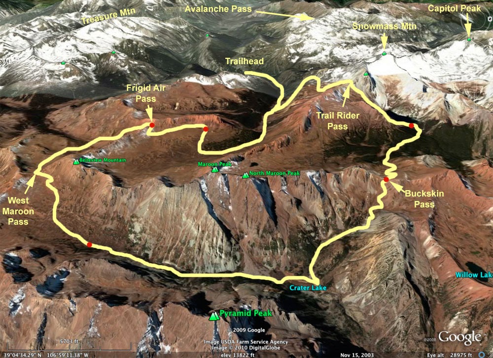
COMPLETED: Maroon Bells Four Pass Loop - Colorado - August 2015


This summer, the hubby and I went to Colorado to hike in the Maroon Bells. This hike is approximately 28 miles long. You go over four mountain passes: West Maroon Pass, Frigid Air Pass, Trail Rider Pass and Buckskin Pass. It is a pretty strenuous hike!

To get here, you'll need to go to the town of Aspen and drive up the Maroon Creek Road. It is unclear from some of the websites that I visited before going - but here is my advice for getting to the trailhead. If you drive up Maroon Creek road before 5:30 PM, the ranger at the guard hut will turn you away and tell you that you need to park in the shuttle parking lot (10 miles back) and take the shuttle bus to the Trailhead. You will need then make sure to end your hike before 5:00 PM in order to take the shuttle back to your car. So my advice is to go up the road after 5:30 PM (when rangers are gone) and start your hike. Or you can beg the ranger to let you go on up ... that is what we did, telling her we didn't know if we'd make it back for the shuttle ... she told us to park at the lower parking lot, which only had a few other cars at it.  

You don't need a permit to hike this loop, but you will need to sign in at a register on the trail.  

Also, bring a bear canister for your food or the rangers will turn you away. The weekend we were here some bears broke into a food cache hung improperly by Crater Lake. So now rangers are requiring bear canisters.

This is a beautiful hike and also very popular. We hiked with many of the same people each day. We hiked clockwise, starting by Crater Lake. We spend 3 nights out. I'm going to warn you -- going over Trail Rider Pass is the hardest part of the hike! We had a really cold night in the Fravert Basin. In the morning we saw frost on the flowers and plants. We filtered our water but noticed some people drinking it without filtering. I err on the side of caution in an area that gets so many visitors. There are many marked campsites. I did not see campsites between West Maroon Pass and Frigid Air - we did both those passes on the 2nd day of hiking. We had beautiful weather but be prepared for rain. A friend of ours did this hike a week before us and said that it rained every day! The wildflowers were plentiful and stunning - I've never seen better!

Map used: National Geographic Maroon Bells, Redstone, Marble Trails Illustrated Topographic Map

Fravert Basin

Wildflowers in Fravert Basin

Meadow below Trail Rider Pass

Snowmass Lake

Thursday

COMPLETED February 2015 ... hiking in Big Bend National Park, Texas

The hubby and I will be heading to 801,000 acres of gorgeousness soon. It will take a 20 hour drive to get to this remote beauty but we'll have fun on the way and we'll be driving through a few states we've never been in.  No real plans have been made once we get to the park, but we plan to hike in the Chisos Mountains, camp at a few remote car camping spots, see the Rio Grande River ... and generally explore the area.  801,000 acres is a lot of area to cover - so I'm pretty sure we won't see it all!  Of course, I'll post about how our hike in the Chisos Mountains goes.

--------

Rio Grande River from Santa Elena Canyon
Actual Trip Report: Hiking in the Chisos Mountains

We explored a lot of Big Bend National Park, although it would take awhile to fully explore all that is there. We did one overnight hike in the Chisos Mountains and it was a beautiful hike!  The hike was only 16 miles round trip but we added a few miles by hiking up Emery Peak on the first day.  Once we got past Emery Peak, there were fewer hikers.   A note on Emery Peak:  it is a nice hike to the top but there isn't a super clear view once you are up there unless you want to scramble onto rocks.

The Chisos Mountains is very much like Arizona's Sky Island's.  The elevation is 7000 feet or more and you are off the desert floor.  The air is cool and moist.  The hike is wooded and lush.  Hiking down Boot Canyon Trail was a treat as it was full of water.  The biggest treat though, is when you get to the South Rim.  Wow!  What a view.  You need to reserve a campsite on this hike and we had the premier campsite closest to the rim. So we set up camp, ate supper and then headed for the rim to watch the sunset.  This sunset viewing ranks at one of my all time best sunset experiences.  My husband had packed a small bottle of wine and while drinking that we texted pictures of our view to family and friends.  It was so beautiful - I wished that everyone could see the beauty!  (Because of our elevation, we had a strong cell signal - best we had on the whole trip!)

Sunset on South Rim looking back at Emery Peak


We had a cold night up on the South Rim.  It was also very damp.  I was very very cold because I didn't have the down sleeping bag. The hubby and I had been swapping the down bag every other night and this night it was his turn to have it.  After that cold night - I think we need to invest in another down sleeping bag!

After a cold night like that, coffee tastes terrific!  And then we were off and hiking out.  The hike out on the Laguna Meadow Trail was a much easier hike than the day before.  There was a lot of down hill hiking.

We didn't see any bears or mountain lions or peregrine falcons on the hike.  We did see a black squirrel, a deer, a Mexican Jay and lots of other birds.  Later in the week, we saw a coyote running on the paved park road.  We also saw a lot of road runners and a blue heron on the Rio Grande.

Later that day we were down and out of the mountains soaking in the natural Hot Springs.

Map used:  National Geographic Big Bend National Park Trails Illustrated Topographic Map


---------

Notes on Big Bend National Park

There is a lot to do here if you like being outdoors.  You can get a week of car camping sites for $10 - so you can camp cheaply here.  The car camping sites have no amenities (no electric, no bathrooms).  Our favorite car camp spot was by Gravel Pit.  You could walk to the Rio Grande River from there.  Also, a 5 minute drive would bring you to Rio Grande Village, which is just a campground, a Ranger Station and a Store with showers, laundry and free wifi.  The Hot Springs are also close by.  There is an interpretive center by Panther Junction which is worth checking out.  A raft or canoe trip on the Rio Grande is another fun adventure to try.  If you want to go out for dinner there is a restaurant at the Lodge in the Chisos Mountains or else you can drive to Terlingua.

Notes on weather: We experienced all sorts of weather conditions in February.  In the desert during the day it could get up to 80 degrees or higher. At night it got cold and we'd wake up to 30-40 degree temperatures.  One morning it was raining so we packed up and went to the Lodge in the Chisos Mountains. On the drive up we saw ice on the trees and scrubs.  So it is good to have a heavy sweatshirt or light weight jacket and even a winter hat - especially for hiking in the Chisos Mountains.

Saturday

COMPLETED 2014: Maah Daah Hey Trail (north 96 miles) and the Maah Daah Hey II (south 46 miles)

In late July/early August 2014 a friend and I hiked the whole Maah Daah Hey Trail.  It was our second time hiking the top 96 miles and our first time hiking the bottom and newest section of trail -- what is known as The Deuce.

I don't have any pictures this time because I decided to use video.  Here are some notes for any of you who plan on hiking this trail.

We were fortunate to have a mowed trail.  It was mowed for a mountain bike race that happened the first weekend of August.  If it had not been mowed I think our hike would have been a tangled mess!  I say this because the parts of the trail that were in the North and South Units of Theodore Roosevelt National Parks were not mowed and were a mess!  We actually got lost on the two miles of trail in the North Unit because the trail was so overgrown.  There are sections of trail in the South Unit that are pretty overgrown too - wear long pants while going through them if you want to have skin left on your legs.

I had forgotten how hot it gets in the Badlands.  In my opinion, it makes good sense to start hiking at 4:30 in the morning until Noon, rest all afternoon and resume hiking in the cooler hours 6:00 to 8:30 pm.  It can be hard to sit around all afternoon but if you don't you can't possibly have enough water to beat the heat.  Hiking in the heat I can easily drink 32 ounces (one Nalgen) in two miles of hiking.

Water.  In heat it can be an issue.  We started the hike up at the CCC Campground and planned on getting fresh water 38 miles south at Magpie Camp.  Except that when we got there, the pump didn't work.  Turns out, someone had stolen the copper from the pump.  I don't know if it has been fixed yet.  (As of Summer 2014 Magpie Campground pump doesn't work.)  Elkhorn Camp and Wannagan Camp both have working water pumps.  You can filter or boil water from cattle stock tanks or the creeks.  Creek water is usually not the best quality.  I've never drank water from the Little Missouri River as it is too silty.  We stashed water on "The Deuce".

The top 96 miles of the Maah Daah Hey is much rougher country than the 46 miles of "The Deuce".  Much rougher.  I actually prefer the top 96 miles of trail over the lower 46 miles even though the top 96 is a harder hike.  I like the scenery of the top 96 miles better.  The lower 46 miles is mostly rolling grassland but there is a nice overlook of the Little Missouri on the lower section of trail.

Shuttle.  Dakota Cyclery offers a shuttle service.  We used it - great folks!

Solitude.  If you like solitude you'll get it here.  We didn't see any hikers until we got to the South Unit of Teddy Roosevelt Nat'l Park.  We did see some oil workers and a rancher.

Cellphones.  On higher ground you often get a signal.  I was able to get a text out every day to let family know how I was doing.

Animals.  There are buffalo in the north and south units of TRNP.  So watch out for them.  I know there are mountain lions in this area.  We saw their tracks and we think we saw one of their kills (a mauled deer).  Just be aware in the wooded draws, especially at dusk and dawn.  I've heard the best defense against them (they rarely attack humans) is to stand up to them and look big.  Rattlesnakes can be an issue but we didn't see one on this hike.  There are lots of harmless cows and some bulls.  Be on guard for the bulls - but they should leave you alone.  They are out there scoping the ladies and that is pretty much all they have their mind on.  I have also seen a ram out there and antelope and deer.  There are coyotes out there.  They are pretty harmless but they howl a lot and can keep you awake at night.

This is absolutely beautiful country.  I wish I was out there now.

Map used for top 96 miles:  National Geographic Theodore Roosevelt National Park Trails Illustrated Map / Did not have a map for the lower section of trail

Note:  Video is best viewed small (not full screen).


Monday

COMPLETED 2013: Four Days on the Camino de Santiago, Spain

This is a fun hike - it is a little different from wilderness hiking because you hike from town to town, stay in dorm style hostels at night and you meet and become friends with other hikers from around the world along the way.

But if you like to walk - the walking is still the same.  The group I was with put in some pretty long days:  15 miles, 12 miles, 13 miles and an 18 mile day.  And you still get blisters!

We took a train to Pamplona from Madrid and started our hike from there.  We ended the hike in Longrono.   Because we did this in April, we did not have any problem getting a bed in the hostels along the way.  It was a wonderful hike:  there were lots of hills and we hiked through wine and olive country.  Each little town was perched on a hill, had a huge church in the center and many of the towns still had medieval walls.

We used this guidebook:  A Pilgrim's Guide to the Camino de Santiago by John Brierley.


Wednesday

COMPLETED: Summer 2012 - Wind River Range, Wyoming Hike

We are going to the Wind River Range for our first year of marriage anniversary! This could either be called our Anniversary Hike or the 4th Honeymoon. Take your pick. We are planning a 4 day/3 night hike. This will be our longest hike together. This shouldn't come as a surprise to me, but I've found my husband is a stronger hiker than me. He doesn't get as tired as quickly as I do and he hikes faster than me. Now don't everyone gag from me saying this, but we make a great team hiking just like we make a great team in normal life. I can't wait to experience the beauty of the mountains with him this summer. We start the hike in the woods and then move above the treeline. The plan: Day 1 -Start at Big Sandy Trailhead. Camp at Shadow Lake or beyond. Day 2 - Over Texas Pass and camp near Lonesome Lake by the Cirque of the Towers. Day 3 - Hike to Big Sandy Lake. Day 4 - Get up early to hike up to Temple Pass and beyond for views of the northern Wind River Range. Then hike out. I'm hoping the hike out is easy - since we'll be losing elevation. After the hike we'll to treat ourselves to a massage and great food in Jackson, WY.

* * *

Hike Update: Well this is what we actually did.  We drove up to the Big Sandy Trail Head.  What a drive!  It was a beautiful drive but 1.5 hours long and on gravel roads.  

The first night we stayed up by Clear Lake.  At first we thought we had the whole lake to ourselves but then a pretty big group made it up to us with help from their llamas.  The lake was gorgeous and ultra cold.  Also their were a lot of mosquitoes.  (Take spray or better yet, mosquito netting.)

The next morning we got up planning to hike over Jackass Pass.  We started on our way up and ended up spending a lot of the afternoon at Ford Lake because there were no mosquitoes there.  We set up camp here and decided to hike up to the pass with a light pack that held our supper.  Just over the pass we made supper and ate it to a view of the Cirque of the Towers.  The view was well worth the hike.  After supper we hike a bit more and saw Hidden Lake and Texas Pass, which had a lot of snow on it.

After the hike out, we stayed at Big Sandy Lodge in a little cabin with no electricity.  But they do stock the cabins with an oil lamp and the cabin has a wood stove.  The nights get cold and the stove keeps you toasty warm.  There are showers and running water and the beauty of it is - you don't have to listen to an ugly generator.  The owners of the place also have a lodge at which they serve meals (which cost extra).  We had a blast eating with all the other lodge guests and after dinner we played games and worked puzzles with them all.  Fun!

Map used:  Earthwalk Press South Wind River Range Hiking Map and Guide


Overall, the trip was an A+.  Great scenery.  Not too many people. Awesome lodge at the end.

Note: You don't need permits.  The trails are pretty well marked in this area.

Monday

COMPLETED Florida Overnight Hike - Jonathan Dickinson State Park - February 2012


My husband and I are going to go on a small overnight hike at Jonathan Dickinson State Park in February. It will be a nice change for us to experience the Florida outdoors - the sounds, smells and sights. Can't wait to make the memories.
---

Update: We spent one night camping in the park. We had a 7.5 - 8 mile hike to our campsite. The air was steamy! We heard and saw a pileated woodpecker - what a lot of ruckas he made - and he is huge! I guess there are two birds (or two pairs?) in the park. I wondered what those wooden sticks were growing out of the ground and later found out from the park rangers that they are Cypress Knees. Hiking out, we stopped for a break in the shade and a turtle (golpher turtle?) came over to check us out. We got rained on the last mile of the hike but it was a soft, warm rain and it felt great!

Sunday

COMPLETED: Theodore Roosevelt National Park Hikes - Sept 2011


My husband and I did two overnight hikes. The first one was in the North Unit of the Park on the Achenbach Trail. We did not actually hike this trail as it was pretty overgrown and we were having problems staying on the trail. We did spend the night though. I did not feel bad about not doing this hike. The ranger told us they had to do a search and rescue the prior week. In the morning, we had a lone buffalo come into our camp. He stood right behind the tree in the tent picture and looked at us. We went into the tent until he lost interest and went away.

We did an 11 mile loop hike in the South Unit the next day on the Petrified Forest Trail. We had a wonderful night in the park, even though a congregation of coyotes barked and yipped and carried on all night. In the pictures you can see some petrified rock and a picture of the Little Missouri River.

I had a chance to talk to people in Medora and Sully State Park about the 40 miles of new trail added to the Maah Daah Hey Trail. I'd love to hike this section of trail sometime soon!

Tuesday

COMPLETED: Arizona Trail - April 2011 - Mexico Border to Tucson


This hike has been completed! I had a wonderful time with my friend, Kirsten. This was sort of a "Bachlorette Party" hike as I was to be married 2 months later. I am now married and I'm still hiking, but more on that later. We decided to start the AZ hike in Patagonia (to avoid illegals at the border as much as possible) and we hiked up to Summerhaven, a town in the Catalina Mts. This was a tough hike! The toughest park was getting over the Rincon Mts and through Saguaro Nat'l Park in a day (due to not having permits) -- and we did it! We experienced a lot of hospitality along the way: 2 different couples gave us food, lodging and a shower! So we were well feed and rested and had lots of company. One of the best parts of the hike was hiking in the Catalina Mtns. Of course, the pizza we ate at the end of the trip was a hightlight too!

Day 1 -Santa Rita Mtns. Mt. Wrightson Wilderness. The first day we had a lot of uphill hiking with our packs at their heaviest. Wonderful scenic views in this wilderness. We camped near an old mine shaft near Gardner Rd. It was a very windy night and I was nervous about illegals and woke up a lot! But overall a good start to hike. "Just think, we have two weeks of this," I said happily to Kirsten.

Day 2 - We can't find where the trail picks up after Gardner road and lost a lot of cool morning hiking hours. It was a slow, hot slog to Kentucky Camp (old mining outfit) and when we got there, we decided to stay here. Both of us are sore - our hips, shoulders and I have 2 blisters - our packs are heavy! Kentucky Camp has fresh water, a microwave for ramon noodles, a shower and adirondack chairs! Kentucky Camp is being restored -- there is a cabin you can rent, a house that is being restored and other historic mining apperatus. They have a caretaker and these caretakes come a month or two at a time.

Day 3 - Finally got a cell signal near end of the day. It was only strong enough to send a message to my fiance and tell him we were OK and could he let Kirsten's family know she was OK. Camped near a road and had some truck headlights shone on us this night. "We are hikers!" I shouted down to the road. I guess when there are illegal problems people are wary of strange glowing tents in the night.

Day 4 - We woke up stinky. This is what I wrote in my journal. :) We were hiking towards Twin Tanks for water. What a disappointment when we got there. It was a cow pond and the water looked disgusting. We met a couple that lived in the area (Dave and Nancy) here. They were taking a walk with their dog. Did we want to fill up on water at there house? You bet we did! We had such a wonderful time with this couple that we ended up staying the night with them. Fun! They told us they'd pick us up in Summerhaven too. Wonderful!


Day 5 - We met thru-hiker, Anthony Culpepper, on this day. He was at the start of a 6000 mile hike. He hikes 25 mile days. He told us he was hungry all the time and his feet ached constantly. I didn't doubt it. Kirsten and I took a break under the I-10 underpass. It was cement and cool while all around us was blazing hot desert. We camped at Three Bridges that night. Although people told us that the illegals disipated at I-10 - I was nervous at this campsite. There were a lot of hooting owls and trains coming and going all night. I was glad to be out of there the next morning - even though it was a beautiful, lush campsite.

Day 6 - We hiked to Colossal Cave on this day. We stopped for food at the ranch before the caves. We took a cave tour next. Then camped at fee campsite nearby. There was fresh water and we washed up and rehydrated. Easy hiking day. No cell signal. I'd like to talk to my fiance, but can't. Poor Kirsten has to hear a lot of fiance stories until I start reading "My Antonia".

Day 7 - At 9:30 am we were at Pistol Hill Road. We were headed towards the Rincon Mts and Saugauro Nat'l Park. Kirsten wanted to take a shortcut on the X-9 Rd. A mountain biker we met told us there was a gated community at the end of this road and we wouldn't be able to get through - but we went this way anyway as it would shave time off our hike tomorrow and we heard that part of the trail ahead was under construction. We didn't get through. A couple in the community suggested we spend the night with them and they'd take us to the Medrona Ranger Station and the trail the next morning. So we enjoyed margaritas, guacamole and steak with this nice couple and their freinds.

Day 8 - So here we were climbing up Mt Mica in the Rincon Mountains. We needed to get all the way across the park in day since we didn't have permits to stay in the park. It was a long slog and was very much like being on a stairmaster all day. To make things worse, we took a few wrong turns on side trails. It was also getting cool up here. We passed Italian Spring and finally camped that night. We were exhausted.


Day 9 - We start the morning with a hot cup of coffee. Then we are off down the mountain. There are wonderful views coming down the mountain. And it is great to be going downhill!


Day 10 - We met the Vagabond Birder at Moleno Basin campground. He is the resident campground host. We'd had a stock tank bath earlier that day -- so we were looking pretty good for socializing. Later in the day we hike to Gordon H(?) Trailhead. We stop and camp at a place where we had a cell signal. We need to let Dave and Nancy know we are on track to meet them at Summerhaven. We manage to get a message through. We relaxed that night with a meal of oatmeal with craisins. A very loud bumble bee joined us for supper.


Day 11 - We were up at 5:20. Gorgeous hike in the Catalina Mountains. At one point we accidentally took the Palisades Trail. Very demoralizing turn of events. Finally though, we made it to Hutch's Pool. Wow. What an oasis. You can submerge you whole body in this big pool. There is even a beach. We had relaxing time and the pool all to ourself the whole day. We read, journalized, did laundry, cleaned up, made tea ... bliss! Kirsten is longing for a hotel and I am longing for a hamburger.


Day 12 - We get an early start again. We are walking uphill again, towards Mt Lemmon. It is a tough hike. We are looking for Wildeness of Rocks Trail. Where is it? Did we miss it? We give each other high-fives when we see the trail sign and are in high spirits. About 2 hours from Summerhaven I need to stop to eat. I was so sick of my granola bars that I hadn't been eating and now had no energy. I eat some of Kirsten's trail mix. Then we are off again ... then we are in Marshall Gulch ... and then we are at the end of the trail!!! Hooray! We did it!

Estimated mileage on this hike: 140?

Map used: We bought a guide book and maps from the Arizona Trail Association.  Also, one of the Passage Stewards emailed us some maps with more detail for the area we were going to hike.


* * *


Who is going: 2 confirmed hikers
Mileage: approx. 180 miles

We'll take a shuttle ($70/Arizona Sunshine Tours) from Tucson to the trailhead near Mexico border and hike North. After 3 days of hiking (17 mile days), we'll have a rest day in Patagonia. We'll hike right into the town! Back on the trail, we'll probably put in 12-15 mile days. We have some strenuous hiking in Rincon Mountains and somewhere in there we'll have to hike 14.5 miles through the Saguaro National Forest because we won't be able to camp there (not able to pick up permit). We'll end the hike with a 10.5 mile walk to Tucson on the Catalina Highway.

Concerns: running into illegals near Mexico border, staying warm in the higher altitudes, water
Highlights: possibly seeing havalinas, experiencing "sky islands" in Miller Peak Wilderness, walking through Kentucky Camp (old mining camp)

For more info: http://www.aztrail.org/ This site gives you updates on the trail. You can contact actual people! (Passage Stewards) who will give you accurate info on trail conditions, etc. (I'm impressed!)

This hike has been in the plotting and planning stages for well over a year and it is time to go!

COMPLETED: North Country Trail, Pictured Rocks - Upper Penninsula MI - early July 2010


42 miles along Lake Superior from Munising to Grand Marais.
4 nights, 5 days

3 hikers

Shuttle Service: www.altranbus.com/backpack.html
We took the shuttle from Grand Marais to Munising and start of trail and then we start the hike to the car. This worked out really well! We got our permit at the Grand Marais Visitor Center (issued by Park Ranger Brody) and five minutes later, the bus arrived to pick us up.

Permits: http://www.nps.gov/piro/planyourvisit/backcountry.htm
I faxed in my campsite reservations and got a mailed response within a week. My campsite reservations:

Camp at Cliffs after 5 mile hike
Camp at Chapel after 11 mile hike
Camp at Sevenmile after a 12 mile hike
Camp at Au Sable after a 7 mile hike
Last day we hike out 7 miles and we are finished.

After getting on the trail in Munising, it did not take long to get spectacular views from the cliffs. The campsites we were in were not crowded -- it was just us and 1-2 other groups. All campground we were in had bear poles for hanging food. On day three of the hike, we finally left the Picture Rocks cliffs behind us. We then walked along the beach. Some beaches were so lonely -- it was only us splashing around in the water! We hiked on some hot days and the biting flies came out. We were told that these flies come out on hot days all summer long. The flies attack only legs and arms so the only thing we could do is put on long pants. I found that Deet kept the flies off my arms pretty well. At Hurricane Beach, we found that once we were in the water, we were on a sometimes slippery rock ledge. This rock ledge extends out to Sable Point and to the lighthouse. You are able to see some shipwrecks in this area and the Aux Sable Light House. We ended the hike with a meal at a restaurant in Grand Marais -- minutes from the trailhead. Trail time always goes by way to fast. Here I sit home writing about the trip already. Sigh.

Pictures (left to right): Miners Rock, Miner's Beach, Pictured Rock overlook, waterfall, sunset on Twelvemile Beach

Thursday

COMPLETED: Grand Canyon (AZ) - Bill Hall Trail - May/June 2010


The dream of hiking to the bottom of the Grand Canyon to the Colorado River came true! This was a 3 night, 4 day hike. Started at the Bill Hall Trailhead. This is a very strenuous hike. The first day we did three descents and camped at Upper Tapeets campground, an oasis in Thunder Canyon. Thunder Canyon is amazing - the sound of the rushing water and so much of it was "thunderous".  Of course, all the descents had to be ascended again to get out of the canyon!

Notes:  We cached water on the Esplanade for the trip back, but I didn't need mine and left it for future hikers.  If you are scared of heights you might not like this hike.  In order to get to the Colorado River, you need to be on a path that has some exposure (if you fell, it wouldn't be good.)

Highlights: experiencing the heat of Surprise Valley, watching the rafters row down the Colorado, scary path with exposure down to the Colorado.

Pictures (l to r): Thunder River, me sitting in shelter by the Colorado River, view of Colorado and Tapeets River converging, Surprise Valley at the end of the day

Map used: National Geographic Grand Canyon Trails Illustrated Map

Tuesday

COMPLETED: Zion National Park (UT)- May 2010


This was a four night, five day West to East traverse of Zion. The car was parked at the East Rim trailhead. We paid Zion Adventure Company to shuttle us to the Lee Pass Trailhead. Total miles hiked: approx. 50 miles.


Highlights: getting snowed on one night near Wildcat Canyon, Hop Valley, viewing the amazing scenery on the West Rim Trail and Walter's Wiggles (a trail down to Zion Canyon with many, many switchbacks) and a hamburger eaten mid-hike in Zion Canyon.

Pictures (l to r): view of Zion Canyon walking down Walter's Wiggles, view from West Rim Trail, Hop Valley, LeVerkin Creek, start of hike at Lee Pass Trailhead

Sunday

North Country Trail - Croton Dam to 20th - April 2010


The forecast looked mostly good and there was only a chance for some scattered thunderstorms, so we decided to go on a 19 mile weekend hike. We started at the Croton Dam Trailhead and hiked about 7 miles. The sky looked a little like rain and really set a gloomy mood through one dense section of forest. "Even the trees here stick their tongues out at you!" I said because a little tree we passed had a fungus growing out of it that looked exactly like a big ole tongue.


We were in the tent that night and not sleeping yet. There was a big crack of lightening and then a roll of thunder to the West of us. We listened. A few pitter patters of rain hit the tent. Then there was another crack of lightening and a the thunder boomed right above us. The rain came down hard! We listened as the thunder rolled across the sky. There was third large lightening blast and then the thunder was well to our East, rolling. I went to sleep with the rains coming down with me dry in the tent.


The next morning, at 6:00 a.m., there was another small thunder storm but it didn't last long. We at breakfast and were on the trail by 8:00. The mosquitos almost drove me mad in the morning and we didn't have spray. It was a good walk to the 20th Trailhead. We stopped and had a long rest by the White River. We ended the hike around 3:00 p.m. and of course, we headed straight for Sally's Family Restaurant in Whitecloud. Yum.
Pictures (L to R): Sally's Restuarant, Twinwood Lake, trillium, White River, watching train at campsite

North Country Trail - Nichols Lake to Bowman Lake - April 2010


We started hiking at Nichols Lake North. We hiked past Leaf Lake, Condon Lake, Sawkaw Lake and Highbank Lake. The leaves were not on the trees yet, so we had a good view of lakes. Highbank Lake we viewed from a high bank as name suggests. We camped near 16 mile Rd. The next morning we hiked north again. We passed many marshes. I assume these marshes would be great for bird watching. Walked through Sterling Marsh. There were NCT trail workers here building a boardwalk over some of the very swampy areas. Ended hike at Bowman Lake Trailhead. Nice hike! Except for the trail workers we had the whole 17 mile trail to ourselves!


Happily may I walk.
May it be beautiful before me.
May it be beautiful behind me.
May it be beautiful below me.
May it be beautiful above me.
May it be beautiful all around me.
In beauty is it finished.

~Anonymous, Navajo Night Chant

Site Counters
Count

Followers

Recommended Reading ...

Hiking How To ...
- Beyond Backpacking / Ray Jardine's Guide to Lightweight Hiking by Ray Jardine
-Advanced Backpacking by Karen Berger

Adventures in the Mountains ...
- No Shortcuts to the Top by Ed Viesturs
- Breaking Trail by Arlene Blume
- High Adventure: The true story of the first ascent of Everest by Sir Edmund Hillary

Long Distance Hiking Adventures ...
- A Blistered Kind of Love: One Couple's Trial by Trail by Angela and Duffy Ballard
- The Cactus Eaters by Dan White
- Where the Water Divide / A Walk Along America's Continental Divide by Kren Berger and Daniel Smith
- Desert Solitaire by Edward Abbey

Trail Guides ...
- The Maah Daah Hey Trail by Hiram Rogers
- Hiking Grand Canyon Loops, A Falcon Guide

Grand Canyon Reading ...
- The Man Who Walked Through Time by Colin Fletcher
- Over the Edge: Death in the Grand Canyon by Michael Ghiglieri and Thomas Myers

Isle Royale Reading ...
- The diary of an Isle Royale school teacher by Dorothy Peterman Simonson
- Ingeborg's Isle Royale by Ingeborg Holte
- The wolves of Isle Royale : a broken balance by Rolf O. Peterson